Abstract
This paper presents data from first measurements of total
electron content (TEC) and its gradient during the solar eclipse of March 9,
1997, obtained with the GPS-radio interferometer at Irkutsk. The interferometer
consists of three receivers (one TurboRogue SNR-8000, and two Ashtech Z-12)
located at the vertices of a triangle and spaced by about 3–5 km. The measured
TEC variations are indicative of profound changes in the ion production process
in the ionosphere attendant on the solar eclipse, simultaneously in a large
volume of space with a radius of at height 300 km at 300 km altitude. The delay
of a minimum value of TEC with respect to the maximum phase of eclipse at 300 km
altitude was about 10 min, and the depression depth of TEC growth varies from 1
to 3**1016m-2. By analyzing the data on TEC gradient
variations, one is led to conclude that the depression of TEC growth during the
eclipse is essentially independent of the longitude and of the latitude (within
the observation ranges 52± 6° N and 104±
11° E).
1. Introduction
Radio probing of the ionosphere during solar eclipses provides important information about atmospheric processes in a wide height range. The literature on the subject is quite extensive. Earlier investigations into ionospheric effects of eclipses were made using predominantly ionosondes. During the total solar eclipse of July 20, 1963, changes in the TEC of the earth's ionosphere were measured by observing the Faraday rotation of polarization of lunar radio waves [Klobuchar and Whitney, 1965].
Some experimental data on the influence of solar eclipses upon terrestrial ionospheric characteristics using methods of sounding by VHF signals from geostationary satellites were obtained by measuring the Faraday rotation. Those measurements revealed the eclipse-induced effect of deep (as deep as 20--30%) TEC depression in the ionosphere, with a typical time of TEC decrease and recovery of about one hour and with the delay with respect to the maximum phase of occultation ranging from a few to tens of minutes [Cohen,1984].
The new potentialities of remote diagnostics of the ionosphere are based on using standard measurements of transionospheric radio signal characteristics and coordinate-time measurements through the use of dual-frequency multichannel receivers of the global navigation GPS system. These receivers make highly accurate measurements of the group and phase delays between the receiver on the ground and the transmitters on the GPS satellites in the reception zone [Hofmann-Wellenhof et al., 1992; Melbourne et al., 1994] almost at any point of the globe and at any time simultaneously at two coherently-coupled frequencies f1=1575.42 MHz and f2=1227.6 MHz.
The merits of using GPS receivers, combined with a high level of technology and computerization of the system, awakened ever increasing researchers' interest when studying ionospheric effects of disturbances of a natural or artificial origin, such as earthquakes [Calais and Minster, 1995]; spacecraft launches [Calais and Minster, 1996]; and industrial explosions [Fitzgerald, 1997].
This paper presents preliminary results derived by investigating ionospheric effects of the March 9, 1997 solar eclipse using data from the “GPSINT” interferometer that was constructed in Irkutsk. Continuous measurements with this new instrument got underway on March 5, 1997.
A solar eclipse was observable on March 9, 1997 in the northern part of the eastern hemisphere [Espenak and Anderson, 1995]. The band of totality on the terrestrial surface started at the location 49° N, 87° E, on the Russia's China frontier and continued on the territories of Mongolia and Russia. The largest width of the path of totality was about 370 km. At ionospheric heights the path of totality was much farther to the south.
Figure1 shows a schematic map of the southern part of East Siberia where our observations were made. Dashed lines represent the equal maximum phase of eclipse Pmax at the height H=300 km corresponding to the phases: 0.14, 0.10, and 0.06; Pmax is equal to the ratio of the visible area of the solar disk to its total area. The height of 300 km was taken with some degree of convention in order for it to be tentatively referenced to the ionospheric F2-region electron density maximum.
The phase of eclipse at the ionospheric height can differ by more than an order of magnitude compared with the value of Pmax on the terrestrial surface. The time Tmax for H=300 km over Irkutsk is 1.3 min ahead of that on the ground. The difference in the values of Tmax and their onset times is due to the relatively low altitude of the Sun. At the time of the largest phase in Irkutsk (00:54 UT) it was as low as 11.5° .
Following are results derived by processing the data of transionospheric sounding by signals from four satellites (PRN01, PRN14, PRN25, and PRN29) observed simultaneously at the three sites of the GPS-interferometer without technical failures from 00.00 and 02.00 UT and visible at zenith angles q less than 60° . Our choice of zenith angle values not exceeding 60° was dictated by difficulties of interpreting the data with very low line-of-sight (LOS) angles of elevation at satellites because, unfortunately, the time of passage of the Moon's shadow coincided with the most clearly defined morning transient process (for example shock wave as a result of pass of terminator) and general change of TEC due to dawn in the ionosphere. Even for 60° , the distance between subionospheric points at 300 km altitude for the widest spaced PRN01 and PRN14 was about 800 km or one time zone. Under such conditions, the ionosphere for PRN01 was an “almost dayside” ionosphere, and for PRN14 it was an “almost nightside” ionosphere. For the lowest angles of elevation, this difference would be still more pronounced.
Circles in Figure 1 enclose areas with subionospheric points at H=300 km for selected satellites visible from Irkutsk in the range q from 0° to 30° and 60° , respectively. The figure also shows trajectories of subionospheric points for 300 km altitude, corresponding to directions to the GPS satellites used in the analysis; asterisks show the location of subionospheric points at the time of the maximum phase of eclipse at H=300 km.
Values of Tmax and Pmax used in the analysis are presented in the Table 1 for each satellite. The table also lists locations of subionospheric points (Xmax, km) and (Ymax, km) in the Cartesian coordinate system with its origin at point B and the x- and y-axes are directed to the east E and to the north N, respectively.
According to observations at the magnetic observatory Irkutsk, the day of the March 9, 1997 eclipse was quiet, with the diurnal sum of K-indices amounting to 10. March 8 and 10 were also relatively quiet days, with the diurnal sums 16 and 11, respectively. This enabled us to circumvent difficulties arising when analyzing ionospheric effects of a solar eclipse under conditions of a disturbed ionosphere.
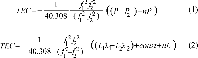
A method of reconstructing TEC variations from measurements of the ionosphere-induced additional increment of the group and phase delay of the satellite radio signal was detailed and validated in a series of publications [Hofmann-Wellenhof et al., 1992; Melbourne et al., 1994; Calais and Minster, 1995, 1996; Fitzgerald, 1997]. We reproduce here only the final formulas
where P1 and P2 are additional paths of the radio signal caused by the group delay in the ionosphere, m; L1l 1 and L2l 2 are additional paths of the radio signal caused by the phase delay; L1 and L2 represent the number of phase rotations at the frequencies f1 and f2; l 1 and l 2 stand for the corresponding wavelengths; const is the unknown initial phase ambiguity; and nP and nL are errors in determining the group and phase path.
For the sake of convenience when representing TEC data, in current publications a convention uses the unit TECU=1016 m-2. Typically, the range of TEC variation during 24-hour period is 30--60 TECU depending on geophysical conditions.
Phase measurements in the GPS can be made with a high degree of accuracy corresponding to the error of TEC determination of at least 10-3 TECU when averaged on a 30-second time interval, with some uncertainty of the initial value of TEC, however. Group delay measurements furnish an opportunity to determine the absolute value of TEC, but with an error worse than 10-1 TECU when averaged for 30 s [Melbourne et al, 1995].
Group delay measurements did not ensure the required accuracy of TEC determination. In this paper we therefore limit ourselves only to TEC variations obtained from phase delay measurements by formula (2). For definiteness sake, we bring the TEC variations into the region of positive values with the minimum value equal to 0 by adjusting the constant term const in equation (2).
The capabilities of reconstructing the space-time distribution of TEC within a wide cone of angles over the site of observation can be considerably extended through the use of the several GPS receivers set up in interferometer-likely to make additional measurements of TEC gradient for each GPS satellite observed at a given instant of time.
The high stability of reference generators on satellites and in dual-frequency receivers, and also the high level of technology of processing of phase measurements in GPS permit the recording system and the software complex for combined processing of data from spaced GPS receivers to be regarded as a radio interferometer. Similar systems which use, as the signal, the radiation of discrete radio sources [Mercier, 1986] or signals from geostationary satellites [Jacobson et al, 1995], have recently been widely used to study the dynamics and structure of ionospheric irregularities of a wide range of scales, from a few to thousands of kilometers.
The geometry of the GPS-interferometer at Irkutsk is presented in Figure 2a. Here A, B, and C are the reception sites spaced by about 3--5 km where dual-frequency multichannel receivers were installed (one TurboRogue SNR-8000 – C, and two Ashtech Z-12 – A and B). Parallel lines show the lines of equal TEC according simple model; the arrow shows the direction of a normal a to these lines; and N and E are the directions to the north (axis Y) and to the east (axis X). The longitudinal and latitudinal components of TEC gradients GE=d(TEC)/dx and GN=d(TEC)/dy were determined through linear transformations of TEC differences for the pairs of reception sites (TECA–TECB) and (TECC–TECB). If absolute values of TEC are known for each receiver, this makes it possible to determine not only the absolute values of gradients but also the direction of a normal a to the lines of equal TEC. In the present case, however, for technical reasons, we were not able to do this. For the purposes of this paper, we confine our consideration to gradient variations only. For a sake of simplicity, we bring the variations of TEC gradients into the region of positive values, with the minimum value equal to 0.
The results presented below were obtained when recording GPS data with 30 s sampling rate; essentially, all processing of phase measurements was limited to the determination of TEC by formula (2). We used the 15 min sliding window averaging technique only when plotting determined TEC gradient in order to avoid crowding of Figure 3.
With an accuracy of TEC phase measurements no worse than 1014 m-2 and the distances between reception sites on the order of several kilometers, the corresponding error of determination of TEC gradients is no worse than 1011 m-3.
We also rejected the usually used conversion of measured variations of “oblique” TEC to the value of “vertical” TEC [Calais and Minster, 1995] because such an approach is legitimate only for a horizontally homogeneous ionosphere, but in our situation this is by no means always the case.
Because of a substantial difference of satellite observing periods, in the selected range of zenith angles it was possible to identify only a two-hour interval of simultaneous measurements for all satellites. This interval, however, totally spans the eclipse cycle, from first to last contact.
All data are plotted for the time interval 00.00–02.00 UT (in minutes with respect to 00.00 UT) where Tmax corresponds approximately to its middle, and to its ends corresponds the time of first and last contact of the solar disk in the optical range at the ground level in Irkutsk. The vertical bar on the plots for each satellite marks the time of maximum phase Tmax at 300 km altitude. The data presented include the day of eclipse plus two reference days (before and after the eclipse).
Figure 2b presents the initial raw TEC time series for PRN25 for March 9, 1997, as seen from the 3 sites: A — solid line; B — dots; C — dashed line. The difference of TEC(t) dependencies for different reception sites was caused by time variations of TEC gradient; results of data processing are presented below.
TEC variations obtained for all satellites (for B-reception site, Ashtech Z-12) on March 8, 9 and 10, 1997, are presented in Figure 3 (PRN01 — 3a; PRN14 — 3c; PRN25 — 3e; PRN29 — 3g). It is easy to recognize dramatic differences in TEC variations for March 8, 10 and 9. All satellites are characterized by almost the same form of monotonic increase in TEC on the reference day of March 8 (and PRN01, PRN14 for March 10) and of the eclipse-induced depression of TEC growth. During the eclipse the value of oblique TEC for PRN14, PRN25, PRN29 starts to decrease gradually immediately after the first contact and reaches a minimum TEC at instants of Tmin. This is followed by a gradual increase and recovery of TEC.
For PRN01, however, one can notice only a slightly appreciable decrease in growth rate of TEC on March 9. The absence of a clearly defined eclipse effect on the PRN01 variations, unlike the other satellites, may be accounted for by the fact that the ionospheric region which makes the decisive contribution to TEC for this satellite, was at a larger distance from the path of the Moon’s shadow.
The main parameters of the TEC(t)-curve that characterize the eclipse effect (Tmin, the response delay dT=Tmin–Tmax, and the approximate depth of depression M, as a difference of background conditions) are presented in the Table 1. Corresponding parameters for PRN01 are not included in the table because the eclipse effect in this case is not as clearly expressed as for the other satellites.
A comparison between Tmax at 300 km and Tmin of the largest TEC response showed that almost for all satellites, whose LOS were directed close to the zenith (PRN25) or north-westward (PRN14 and PRN29), the delay dT and the depression depth M were found to approach 10 min and 1--3 TECU, respectively.
The Figure 3 illustrates a good correlation and similarity of the response forms for PRN14, PRN25 and PRN29, including the onset time of the minimum Tmax. Particularly noteworthy is the difference in the rate of decrease in TEC and the coincidence of the response forms at the station of TEC recovery.
Our data are in reasonably good agreement with published evidence [Klobuchar and Whitney, 1965; a review by Cohen, 1984]. First of all, this applies to the TEC growth depression depth M (a few of TECU according to published data) and to the delay time of the response dT (from a few to 20¸ 30 min).
Variations of gradient components GE and GN obtained for all satellites on March 8 and 9, 1997, are presented in Figure 3 (PRN01 – 3b; PRN14 – 3d; PRN25 – 3f; PRN29 – 3h). Unfortunately, for technical reasons, it was possible to measure TEC gradient on March 8 only after 00.42 UT and only for PRN25 and PRN29. On March 10, it was not possible at all to obtain data of simultaneous measurements for all reception sites.
Time-dependency of TEC gradient for all satellites for March 9 and for PRN25 and PRN29 on the reference day of March 8, is similar in the form and range of variation. The longitudinal gradient GE decreases monotonically with the time, which corresponds to a decrease in the TEC growth rate in this direction as the midday values of TEC are approached. By contrast, however, the latitudinal gradient GN also increases monotonically with the time. A comparison of the variations of TEC gradients for March 8 and 9 showed that the form of variations of the gradients GE and GN for March 9 is similar to the background form.
We have presented the first measurements of TEC and its gradients during the solar eclipse on March 9, 1997, made by the GPS-interferometer in Irkutsk.
The evidence obtained for TEC variations point to profound alterations in the ion production process in the ionosphere during the solar eclipse simultaneously in a large volume of space with a radius of at least 300 km at 300 km altitude. The delay of the minimum value of TEC with respect to the maximum phase of eclipse ranges about 10 min, and the depression depth varies from 1–3 TECU. Our data are in reasonably good agreement with published evidence (see a review by Cohen [1984]). The new element is that such TEC measurements were made simultaneously in four and more directions.
As far as TEC gradient is concerned, such measurements seem to have been made for the first time. The analysis of these data suggests the conclusion that the depression of TEC growth during the eclipse is almost independent of the longitude and of the latitude (within the observed range 52± 6° N and 104± 11° E).
We are indebted to Drs. V. V. Koshelev, K. G. Levi, A. D. Kalikhman, A. G. Barsukov, and V. N. Zheleznyak for help in organizing the experiment and for helpful discussion of results. Great contribution was made by two referees. Thanks are also due to V. G. Mikhalkovsky for his assistance in preparing the English version of the manuscript. This work was done with support from the Russian Foundation for Fundamental Research, grants 96–05–64162 and 97–02–96060.
Calais E. and J. B. Minster, GPS detection of ionospheric perturbations following the January 1994, Northridge earthquake, Geophys. Res. Lett., 22, 15, 1045–1048, 1995.
Calais E. and J. B. Minster, GPS detection of ionospheric perturbations following a Space Shuttle ascent, Geophys. Res. Lett., 23, 15, 1897–1900, 1996.
Cohen E. A., The study of the effect of solar eclipses on the ionosphere based on satellite beacon observations, Radio Sci., 19, 3, 769–777, 1984.
Espenak F., and J. Anderson, Total solar eclipse of 1997 March 9, NASA Reference Publication 1369, 64 pp., July 1995.
Fitzgerald T. J., Observations of total electron content perturbations on GPS signals caused by a ground level explosion, J. Atmos. Terr. Phys., 59, 7, 829–834, 1997.
Hofmann-Wellenhof B., Lichtenegger H., Collins J., Global Positioning System: Theory and Practice, 326 pp., Springer-Verlag Wien, New York, 1992.
Jacobson A. R., R. C. Carlos, R. S. Massey, and G. Wu, Observations of travelling ionospheric disturbances with a satellite-beacon radio interferometer: Seasonal and local-time behavior, J. Geoph. Res., 100, 1653–1665, 1995.
Klobuchar J. A., and H. E. Whitney , Ionospheric electron content measurements during a Solar Eclipse, J. Geoph. Res., 70, 5, 1254–1257, 1965.
Melbourne W. G., E. S. Davis, C. B. Duncan et al., The application of spaceborne GPS to atmospheric limb sounding and global change monitoring, Jet Propulsion Laboratory Publication 94–18, NASA, 1994.
Mercier C. Observations of atmospheric gravity waves by radiointerferometry, J. Atmos. Terr. Phys., 48, 7, 605–624, 1986.
E. L. Afraimovich, K. S. Palamartchouk, N. P. Perevalova, and V. V. Chernukhov, Institute of Solar-Terrestrial Physics RAS SD, p. o. box 4026, Irkutsk 664033, Russia. (e-mail: afra@iszf.irk.ru; kpal@iszf.irk.ru)
A. V. Lukhnev, Institute of the Earth's Crust RAS SD, 128 Lermontov St., Irkutsk 664033, Russia. (e-mail: san@cora.irkutsk.su)
V. T. Zalutsky, East-Siberian Research Institute for
Physicotechnical and Radioenginereeng Measurements, 57 Borodin St. Irkutsk
664056, Russia.
(e-mail: eopsr@niiftri.irkutsk.su)
accepted October 23, 1997.